 This is the largest study of its kind. It maps and analyses the location of permissions for over 220,000 new homes in 12 fast-growing city-regions between 2012 and 2017, including Cambridge, Brighton, Leeds and Newcastle. It is divided into two 'rounds' – 2012 to 2015 and 2015 to 2017, which allows comparison on how spatial issues are changing since the NPPF came into force in 2012.
The national debate around planning and housing tends to focus on three criteria: the number of houses granted permission, the speed at which they are built, and the affordability of the finished product. There is a wealth of data on each of these metrics, and these are increasingly used to measure the effectiveness of the planning system.
But while these are important criteria, they form just part of the picture. Planning is about delivering sustainable development, not just housing numbers. That is why the National Planning Policy Framework (NPPF) includes a wide range of economic, social and environmental objectives which include boosting economic growth, promoting sustainable transport, tackling climate change and improving public health.
Planning can help to deliver these objectives by looking at the big picture and ensuring that new development supports sustainable settlement patterns and urban form. But when it comes to measuring progress, there is little public data and spatial analysis to show the location and scale of new development. Without this data, is it hard to understand whether planning policy is really delivering sustainable development.
Given the significance of these spatial relationships, the RTPI commissioned Hatch to help us gain a better understanding of changing settlement patterns and urban form in twelve fast-growing English city-regions.
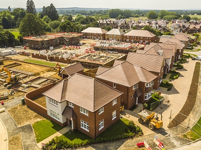
The study mapped planning permissions for over 226,000 new houses granted between 2012 and 2017, focusing on major schemes of 50 or more units. It measured the size of each scheme and its relationship to the existing built-up area, and analysed proximity to major employment clusters and key public transport nodes - just some of the factors that make for a sustainable location.
We found that new housing is being located relatively close to jobs, with 74% of permissions within 10km of a major employment cluster. However, we found that over half of the houses permitted are not within easy walking or cycling distance of a railway, metro or underground station.
More research on the location of development can be found here.


