
How data, technology and governance can combine to drive a new wave of strategic planning
This position paper sets out the complex challenges facing city-regions and the barriers which prevent a coordinated response. New opportunities are emerging across the UK for local authorities to conduct strategic planning, and the smart city agenda shows how data and technology can support this process.
You can read the paper below, or download a PDF version
The UK faces a number of pressing challenges, which include tackling the housing crisis, boosting productivity, reducing inequality and shifting to a low-carbon economy. These cannot be tackled in isolation. Strategic planning seeks a coordinated response across wide geographical areas like city-regions, and across sectors like housing, transport, health and the environment.
Opportunities are developing for local authorities to work together at the scale of city-regions, creating joined-up plans which cover a range of issues. To be successful, they will need to understand complex economic, social and environmental trends, build consensus between a range of stakeholders, and develop long-term plans in conditions of uncertainty. New tools and approaches are needed to support this wave of strategic planning.
The smart city concept describes the use of data and technology to improve the performance of infrastructure networks and create more liveable urban areas. However, the benefits could go much further. Technological innovation can support local authorities as they work collaboratively to develop plans which cover a wider range of people, places and issues. With leadership from the planning profession, we can create ‘Smart City-Regions’.
Contents
1. Strategic challenges facing city-regions
1.1. Boosting economic productivity and inclusive growth
1.2. Housing a growing population
1.3. Reducing emissions and adapting to climate change
2. Opportunities and barriers to strategic planning
2.1. From local autonomy to regional planning and state intervention
2.2. From regional planning to localism and privatisation
2.3. Devolution to city-regions
3. Challenges to the devolution agenda
3.1. Not all places are covered
3.2. Local authorities lack capacity and resources
3.3. Not all issues are covered
3.4. Public engagement is a challenge
4. Smart cities as the solution to urban problems
4.1. A short history of the smart city
4.3. Transforming the planning system
5. Can smart city thinking improve strategic planning?
5.1. What could a smart city-region look like?
6. Learning from practice to make better policy
1. Strategic challenges facing city-regions
1.1. Boosting economic productivity and inclusive growth
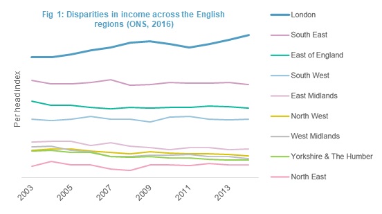
From the 1970s onwards, waves of globalisation and economic restructuring saw the UK transition towards a service and knowledge-based economy. Formerly industrial cities in the Midlands and North of England, along with cities in Scotland, Wales and Northern Ireland, suffered from rising unemployment, outward migration, a declining tax base, and a lack of infrastructure investment. Smaller towns, rural areas and coastal communities were hit particularly hard.[1]
Meanwhile, London and the South benefitted from the growth of financial, academic, technology, science and pharmaceutical sectors, and received more infrastructure investment. This helped them to create urban environments which attracted new businesses and young, highly educated workers.[2]
The fallout from the 2008 financial crisis exacerbated this divide, as productivity slumped, public spending decreased and real wages stagnated. London and the South East recovered fairly quickly, assisted by the bailout of London’s financial sector and continued investment in major transport and regeneration projects.[3] But other parts of the country, already struggling from de-industrialisation, were hit once again.[4][5][6][7]
To address the growing regional divide, political attention focused on driving economic growth in a number of city centres. Places like Manchester, Leeds and Liverpool benefitted from a combination of strong leadership, an existing base of knowledge-intensive industries, and investment in skills, regeneration and transport. But outside these metropolitan areas, smaller towns and villages faced continued cuts to local government finances and a decline in infrastructure funding. This placed a strain on public services, often in areas with sizable immigrant populations attracted by cheaper housing and jobs in industry or agriculture.[8]
This sustained period of uneven growth left the UK with regional differences in productivity which are among the highest in Europe.[9] It fuelled resentment towards centralised policy-making which appeared indifferent to widening inequality and local concerns. The referendum on the European Union emphasised this rift between people and places which benefitted from globalisation and economic restructuring, and those which had not.[10]
1.2. Housing a growing population
For much of the twentieth century, housing growth has been accommodated in suburbs on the edges of towns and cities. At first these were medium-density developments, designed around public transport routes. However, the 1950s marked a shift towards lower density car-dependent housing estates, a model of development made possible by the rise in private car ownership, cheap mortgage finance, changing employment patterns, and cultural preferences for larger homes.
This form of housing came at a cost. As car use increased, public transport declined. Urban centres adapted to accommodate more traffic, with wider roads and new parking spaces. These new roads, coupled with an increasingly mobile population, allowed retail and businesses to relocate on cheaper land on the outskirts of towns and cities. Some inner cities, already struggling from the loss of manufacturing firms, became fragmented, congested and polluted, which further contributed to their decline.[11]
In response, the 1980s and 1990s witnessed a shift towards urban regeneration. Inner cities received investment, and new planning policies encouraged higher density developments on brownfield sites, which supported public transport, walking and cycling. This coincided with the shift towards service and knowledge-based industries, which preferred to locate in well-connected, established urban centres, and created a resurgence in inner-city living.
However, the legacy of earlier growth patterns continued to pose challenges. New business parks, shopping centres and leisure facilities located on the edges of towns and cities, commuting patterns became more complex, and car use led to congestion and air pollution. Green belts, established in response to concerns around urban sprawl, started to displace new housing to more remote locations, which increased journey times, congestion and infrastructure costs.[12i][13] By this point, many successful towns and cities were also suffering from an affordable housing crisis, which spread quickly beyond its origins in London and the South East.[14]
Local authorities are now under pressure to meet ambitious housing targets, while making choices around location, density and accessibility which avoid the mistakes of the past. However, there are few easy solutions. Urban intensification creates housing close to jobs and supports public transport, but tends to be complex and more expensive. The extension of urban areas into surrounding green belt or green field land raises environmental concerns. New settlements require long-term support and commitment from central government.
Faced with barriers to the delivery of large-scale housing, many areas are now at risk from incremental development in locations far from jobs and poorly served by public transport.[15] This is exacerbated by a fragmented approach to infrastructure, where cities struggle to coordinate the wide range of organisations involved in the delivery of public transport, schools and hospitals, water, waste, energy and digital networks. This creates uncertainty for developers, places strain on existing infrastructure, and generates opposition to development from local communities.
1.3. Reducing emissions and adapting to climate change
The threat of climate change has driven domestic and international efforts to reduce greenhouse gas emissions. The UK is legally committed to make an 80% reduction by 2050 (against 1990 levels), and is a signatory to the Paris Climate Agreement which seeks to limit rising global temperatures to well-below two Progress has already been made, with emissions dropping by 42% since 1990, even as the economy grew by over 60%. Much of this was attributable to economic restructuring, as polluting industries moved to other countries, and more recently by the closure of coal power stations and shift towards natural gas.[16]
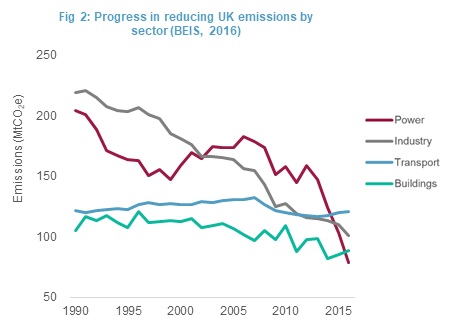
However, as a wealthy country with high levels of consumption, UK emissions remain well above the global average, especially when imported goods are accounted for. The drop in emissions from power and industry has also served to highlight a lack of progress in other sectors of the economy, namely buildings and transport, where emissions remained broadly stable.
This has focused attention on the contribution that planning can make to tackling climate change. This includes shaping the built environment to reduce car usage (which accounts for over half of total transport emissions) and encourage more efficient alternatives, and planning developments which are suitable for low-carbon energy infrastructure, like district heating and cooling networks and electric vehicle charging points. It includes energy efficiency and renewable energy policies for new buildings, and the allocation of land for wind and solar energy to help drive a transition towards a more decentralised and resilient energy system.
City-regions must also adapt to the impacts of climate change, as extreme weather events like flooding, water shortages and heatwaves increase in frequency and severity. Problems of habitat degradation, soil erosion and biodiversity loss, coupled with risks to food production and trade, also undermine the ‘ecosystem services’ which urban populations depend on. These require planning and land management at the scale of functional environmental areas like river catchments, which rarely align with economic and political boundaries.
In summary, strategic planning needs to:
- Drive growth and investment across cities, towns, villages and rural areas, helping all areas to reach their potential.
- Deliver affordable housing in sustainable locations, with the backing of local communities and supported by infrastructure
- Shape urban areas to make radical reductions in greenhouse gas emissions and increase resilience to environmental risks
2. Opportunities and barriers to strategic planning
This section shows how central government has, over time, both encouraged and hindered strategic planning at different spatial scales.
2.1. From local autonomy to regional planning and state intervention
In the first half of the twentieth century, local councils had a high degree of independence. Municipal bodies delivered social housing and infrastructure like public transport, water and gas, but had few controls over the location of housing. In 1947, a comprehensive reformed planning system gave county councils and county boroughs new powers to make development plans. This was coupled with a proactive approach to housing and infrastructure investment by central government, which had embarked on a programme of nationalisation after the Second World War. Local assets and revenue streams transferred to central ownership, which greatly expanded the role of the state.
The decades after the war also saw central government funding major social housing projects and new infrastructure, while New Town Development Corporations built a series of free-standing new settlements. However, the plan-making process was slow, with councils taking time to produce what were effectively zoning plans, and central government taking further time to approve them.
Rapid population growth in the 1960s, coupled with a commitment by the Labour government to a more centrally-planned economy, led to the introduction of regional economic planning and a number of successful regional planning exercises which enabled high levels of housebuilding by the public and private sectors. In 1968/69, a streamlined system introduced Structure Plans, which were intended to cover all areas of the country but be confined to strategic issues.
These ideals were somewhat compromised by the splitting of planning functions between county councils in England and Wales and a new tier of larger “district” councils. The former designated broad locations for housing, transport and environmental protection across local authority boundaries, while the latter made the majority of development control decisions.
2.2. From regional planning to localism and privatisation
Against this backdrop, calls emerged for a more ‘free-market’ approach to policy objectives on economic productivity, infrastructure and housing. Advocates, including politicians and think tanks, argued that markets generated better outcomes without state intervention and direction, which was seen to interfere with ‘natural’ economic laws.[17] These beliefs became influential during the Conservative governments of 1979-1997, when public investment was reduced, and transport, utilities and heavy industries were privatised.
During this period the Conservative government dismantled many of the structures of regional economic planning which had driven growth since the 1960s. However, it soon became apparent that the legacy of earlier regional planning, which included high levels of public and private housing growth in areas like South East England, would not continue for ever. In England, counties were invited by central government to produce draft Regional Planning Guidance, which were submitted to Ministers for approval (and who often made major changes to housing numbers). In 2004 these were formalised into Regional Spatial Strategies, with Structure Plans abolished. These provided a framework for local plans and strategies to follow, and covered a wide range of sectors.
However, growing local opposition to regional housing targets, especially in the South East of England, led the 2010 Coalition Government to dismantle the regional planning system and replace it with a localism agenda.[18] This intended to increase democratic accountability and local engagement by concentrating planning powers at the local authority level, set against a much-condensed National Planning Policy Framework.
Changes were also occurring in other parts of the UK. In Wales, the 1996 local government reorganisation created 22 Unitary Authorities, removing the County Councils and Structure Plans. In 1994, Scotland’s local government structure changed from regional and district councils to 32 unitary authorities, along with joint strategic planning committees in urban areas who published Structure Plans and dealt with cross boundary issues. The 2006 Planning Act removed Structure Plans but introduced Strategic Development Planning Authorities for the four largest city-regions, along with a new National Planning Framework and single Scottish Planning Policy document.
2.3. Devolution to city-regions
Between 1940 and 2010, power and authority in the UK moved gradually from local to central government (although this trend was somewhat countered by the creation of a tier of government for devolved Governments in Scotland, Northern Ireland and Wales in the late 1990s). Planning for related sectors, such as housing, transport, health, energy and the environment, became fragmented as responsibility passed to separate government departments, regulatory agencies and private companies.[19]
This centralised model of government came under repeated criticism from a range of politicians, professional bodies, academics and think tanks.[20] These voices described how sectoral plans and strategies were having unintended impacts in different parts of the country, while local authorities were becoming increasingly dependent on grants from central government.[21] They advocated instead for greater flexibility and accountability, pointing to the success of Greater London and European city-regions which controlled budgets for planning, transport, health and economic development.
The result was a growing interest in devolution to English city-regions, an agenda which has been championed in various forms since around 1997. The London city-region has been the main beneficiary to date, with the Greater London Authority established in 2000 as a strategic authority with powers over transport, economic development and planning. Devolution gained further momentum in 2011 with the creation of the Greater Manchester combined authority, followed by the establishment of business-led Local Enterprise Partnerships to channel European and national funding to city-regions through bespoke Growth and City Deals. The last few years saw a series of more ambitious devolution deals which passed a range of powers, responsibilities and budgets to other newly established combined authorities - groups of local authorities at the city-region scale, generally led by a single elected mayor.
City-regions in Scotland and Wales have also expressed an interest in receiving greater autonomy. In Wales, the 2015 Planning Act allowed for the designation of strategic planning areas, with the Cardiff, Swansea Bay city-regions and A55 Corridor under consideration, and all three receiving City Deal funding. In Scotland, City Region Deals are being developed for Aberdeen/Aberdeenshire, the City of Edinburgh region, Greater Glasgow, Tayside, Inverness and the Highlands and Stirling. These will pool funding from local authorities, the Scottish Government and the UK government.
While devolution in England has largely benefitted London and other metropolitan areas, government statements following the EU referendum indicate a shift towards a broader growth agenda based on “…an economic and cultural revival of all of our great regional cities”.[22] Speeches made by the Prime Minister, Theresa May, described concern for places which had been ‘left behind’, including smaller towns and more rural areas, suggesting a return to a more interventionist government.[23] This was repeated in the proposal for an Industrial Strategy to “…improve living standards and economic growth by increasing productivity and driving growth across the whole country”.[24]
3. Challenges to the devolution agenda
In England, devolution creates the potential for combined authorities to plan strategically across geographical and sectoral boundaries, taking an integrated approach to issues like economic development, housing, transport and health at the city-region scale. At the national level, efforts are also being made to plan across sectoral boundaries, with the National Infrastructure Commission preparing its first integrated assessment of UK infrastructure which looks across the transport, energy, water, waste, digital and flood defence sectors. The 2017 Housing White Paper emphasises the need to coordinate housing and infrastructure in England, and new regional transport bodies are being established in the North and Midlands with the powers to develop multi-modal transport strategies. Calls for better integration have also been made in Scotland and Wales.
Despite these positive developments, there are several reasons why the devolution agenda needs additional support to address the challenges outlined earlier.
3.1. Not all places are covered
After an initial burst of progress, there are concerns that the English devolution process has stalled. 2017 saw fewer new deals than expected, due in part to the breakdown of negotiations for combined authorities in places like Greater Lincolnshire, East Anglia, North East and the Sheffield city-region.[25] And while local authorities in other parts of England have come together to create non-statutory strategic plans and working partnerships, many still struggle to cooperate on matters of strategic importance, like housing, infrastructure and economic growth.
The ‘duty to cooperate’ in the National Planning Policy Framework has helped to address cross-boundary issues in some areas, but lacks sufficient penalties and incentives to encourage agreement and overcome political tensions in others.[26] Outside of London, only 22% of the English population live in combined authority areas with an elected mayor.[27] And around two-thirds of places in England, including many smaller cities, towns and rural areas, are not covered by any form of strategic authority, which makes it less likely that they will receive new powers and responsibilities from central government. Here, strategic decision-making risks being held back by “…tangled levels of negotiation, vested interests and competing mandates”.[28]
Similar concerns exist in Scotland. Many predominantly rural parts of the country are not covered by strategic planning structures, and there are concerns that changes to the planning system may prove insufficient to drive cooperation between local authorities. In Wales, City Deal funding for infrastructure projects still need to be aligned with strategic plans to ensure that they benefit a wide range of people and places.
3.2. Local authorities lack capacity and resources
Local authorities have seen significant and ongoing cuts to funding from central government.[29] The largest cuts have fallen on planning and development services, where single tier and county councils in England have reduced spending by 46%, and district councils by 24%, between 2010-11 and 2014-15.[30] Councils with the largest overall funding reductions also made the greatest cuts to planning and development, as investment programmes for deprived areas came to an end.[31] With planning departments required to fulfil a number of statutory functions like processing planning applications, this leaves less time and fewer resources to address strategic planning issues.[32] In some parts of the country, these cuts make it difficult to develop local plans and are placing the future delivery of homes, schools, hospitals and other major infrastructure at risk.[33]
In Wales, planning services across local government have reduced by 53%, the service with the largest proportional cuts to funding. Scottish planning departments have seen almost 20% reductions in staff since 2010.[34]
3.3. Not all issues are covered
Many local authorities are struggling to implement policies which reduce emissions and increase climate resilience. One analysis of recent Local Plans in England found that 70% had no carbon reduction targets or measures to monitor progress, despite planning policy which sets out the need for ‘radical’ emission reductions.[35] Another found that opportunities for sustainable drainage were being missed, despite clear evidence on their ability to manage flood risk.[36] These issues are compounded by the lack of national policies and strategic direction,[37] coupled with successive waves of planning reform and a prioritisation of short-term economic viability.[38] Local authorities are also held back by a lack of analysis on the wider environmental impacts of national policies. The RTPI’s Map for England project found that housing, economic and transport policies were encouraging high levels of growth in the South East, with little consideration of how this impacted upon future levels of water stress and flood risk.[39]
Some cities instead look to the international stage for support. London is part of the C40 network of global cities committed to addressing climate change, and joins places like Birmingham and Bristol in the international ICLEI Network of Sustainable Cities. Glasgow is part of the Rockefeller Foundation’s 100 Resilient Cities programme. At the 2015 Paris Climate Change Conference, a number of English city leaders joined with international counterparts to make ambitious pledges to run on 100% renewable energy and make 80% emissions reductions by 2050. But despite an urgent need to reduce emissions from buildings and transport, tackle air pollution, and increase resilience to extreme weather, these themes have received little attention in discussions over devolution. Issues of poverty, social exclusion and inequality are also missing from many devolution deals.[40]
3.4. Public engagement is a challenge
Recent polls have shown that most people feel they have little or no democratic control over policy-making by central and local government, including issues which affect local public services and neighbourhoods.[41] Directly elected Mayors in England have been proposed as means to increase political accountability, but face challenges in overcoming traditionally low turnout in local elections.[42] Furthermore, while English combined authorities have new powers to plan strategically, the history of sub-regional and regional planning shows that local communities can feel removed from this process. Recent examples of strategic planning in Greater Manchester show the challenges faced when trying to build a political and public consensus on the challenging issues of housing allocations,[43] while research from the Scottish Government warned of a lack of trust, respect and confidence between local communities and the planning system.[44]
In summary:
- Devolution offers the potential for combined authorities in England to plan strategically at the scale of city-regions, but this agenda is predominantly focused on large metropolitan areas.
- Combined authorities and other bodies with a strategic planning remit need additional support to expand their scope and increase public engagement - all in the context of limited government resources.
4. Smart cities as the solution to urban problems
While the debate over devolution continues, the smart city agenda has emerged as an increasingly popular way for city-leaders, politicians and technologists to frame solutions to urban problems.
4.1. A short history of the smart city
New technologies have always transformed cities, albeit at a fairly gradual, evolutionary pace. But as this process speeds up, its impacts have become more pronounced. Advancements in digital miniaturisation have allowed computers to be embedded into almost any imaginable object in the built environment, including smart phones, vehicles, water pipes, bins, street lights, ticket barriers and buildings[45]. These digital sensors create vast quantities of user information, or ‘big data’, which can be modelled and analysed to improve understanding of human behaviour, infrastructure performance and resource consumption at a greater scale than previously achievable. Cities have also become testbeds for the ‘Internet of Things’: networks of digitally enabled objects connected via the internet. In the energy sector, this includes smart domestic appliances like thermostats, washing machines and televisions that can be controlled remotely, and power down in response to signals from national grid to reduce peak energy demand. In the transport sector, sensors in vehicles and roads provide information which helps manage traffic flows and reduce congestion, while in the water sector, smart meters help utility companies to identify leaks.
As technologies have become embedded into buildings, infrastructure and personal devices, they have encouraged the conceptualisation of cities as networks of integrated physical, digital and human systems.[46] Definitions of the smart city describe urban areas which use “…information and communications technology to enhance liveability, workability, and sustainability”,[47] and those which have “…developed technological infrastructure that enables them to collect, aggregate, and analyse real-time data to improve the lives of residents”.[48]
4.2. A tech-driven agenda
Major technology firms have been quick to enter this market, with companies like IBM, Cisco, Microsoft, Siemens and Hitachi developing products and services which explicitly target urban infrastructure. Governments have also recognised the potential for new ways of working. The European Commission has been exploring how smart cities can boost sustainable urban mobility, improve the energy efficiency of buildings and manage separate infrastructure networks, like energy, transport and ICT, as an integrated system.[49] The UK Government has created new organisations to drive this agenda, including the Technology Strategy Board and its Future Cities Demonstrator Programme, the Future Cities Catapult, and the Energy Technology Institute. These are assisting cities as they adopt new technologies like smart ticketing, city dashboards, and real-time transport data.
With the rise of open data, tech start-ups are creating mobile apps which improve the interactions between citizens and the infrastructure networks which underpin public services. Large technology companies are also having a visible impact on the city. Google, Uber, Volvo and Tesla are planning new urban mobility services, including fleets of autonomous vehicles, which could complement or compete with traditional public transport. In 2016, Alphabet Inc. launched Sidewalk Labs, a company focused on urban solutions and ambitions to build a new city from scratch.
Innovation has tended to focus on the challenges experienced by global cities, those with strong technology sectors, skilled labour markets and digital infrastructure, and local governments which have the capacity to experiment and enter into partnerships with the private sector.
4.3. Transforming the planning system
The planning system has itself adapted to technological change over time, such as the transition to online planning applications and use of GIS. A range of companies now provide data and software to local planning authorities for spatial analysis, land referencing, processing planning applications and monitoring development. In recent years, planning departments have started experimented with 3D modelling software and Virtual Reality (VR) to improve plan-making and community engagement.
However, the efficiency gains enabled by new technology have been countered by increased complexity in the planning system. New legislative requirements and the rising use of legal challenge can lead local planning authorities to commission large amounts of costly technical evidence to support local plan preparation and development management decisions, which adds time to the process and makes it harder for non-professionals to engage. Areas of the planning system have also been slow to adopt new technologies and approaches when compared to the pace of change in the private sector.
In response, the government’s Future Cities Catapult has been working to accelerate the use of new technology and data in planning, bridging the gap between tech-sector innovation and local planning departments.[50] They have identified solutions which could lead to quicker and more responsive plan-making, simplify the application process, improve community engagement, and introduce more consistency into development management. This creates the potential to reduce the time spent by planning officers on administrative tasks, could free up capacity to focus on more complex and strategic issues.
Smart cities also create new challenges for planners. The systematic collection of personal data, much of it location-specific, raises concerns about ownership, privacy and security. New software requires procurement, contract management and user training, and requires interoperability with other IT systems used by local government.
Private-sector innovation can also benefit certain people and places over others, as advocates for new technological solutions may not have regard to the wider principles of economic, social and environmental sustainability that shape planning policy. Some of these tensions are visible in debates over the future of transport, with proposals for autonomous vehicles and Hyperloop technology seen by some as a distraction from more inclusive low-tech solutions like buses, walking and cycling.
5. Can smart city thinking improve strategic planning?
“…the smart city concept not only points to the importance of exploration of modern technologies, but also more importantly highlights the possibility of new kinds of joined-up approaches” [51]
To date, the smart city agenda has been driven largely by actors from outside the planning profession: a combination of technology companies, government agencies and start-ups. But this concept of ‘smartness’ has been used in another context with much relevance to strategic planning – the long-standing debate around how towns and cities should grow.
In the US, the theory of ‘smart growth’ emerged during the 1970s an alternative to urban sprawl. Its advocates, many of whom were planners, championed the benefits of compact, walkable, high density neighbourhoods, and urban expansion along high-frequency public-transport corridors.[52] This ‘smart’ approach to planning:
- considered urban growth at a range of different scales, from the design of houses and neighbourhoods to the shape of entire city-regions
- considered urban growth across a range of different sectors, particularly linking transport and land use, but also considering issues like energy, water, public health and climate change
Importantly, this smart approach started not with technology but with governance. Advocates were looking for ways of working across geographical and sectoral boundaries to resolve conflicting policy agendas, negotiate between different actors, and produce commonly agreed outcomes.[53] New technologies could help to achieve these objectives, but were not presented as ends in themselves.
A new focus on ‘smart city-regions’ would seek solutions which benefit not only major cities but also their surrounding towns, villages and rural areas, working towards the broader economic, social and environmental objectives of planning. In the current context of English devolution, there exists a valuable opportunity to direct the technological innovation of the smart city agenda towards the specific challenges that combined authorities (and other groups of local authorities) face when planning across geographical and sectoral boundaries.
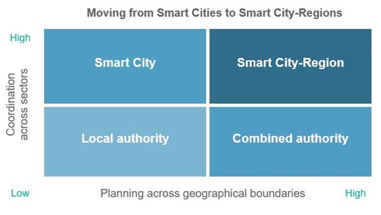
5.1. What could a smart city-region look like?
There are already numerous examples of city-regions which are taking a smart approach to strategic planning. The Greater London Authority (GLA) has been working with local authorities and the private sector to explore the potential of standardised data, mapping platforms and modelling software, and combined authorities are following suit. Meanwhile, new datasets and analytical tools are constantly emerging from national organisations, universities and tech companies which offer innovative ways for local authorities to plan collaboratively on a wide range of issues. A selection of these approaches are described below.
Consistent monitoring of development using shared, standardised data
The London Development Database (LDD), managed by the GLA, requires the London Boroughs to submit information on planning permissions into a centralised system, which can then be tracked through to completion. The use of a single database provides the GLA and London Boroughs with a consistent and efficient way of monitoring development across the city-region, which in turn makes it easier to understand whether key economic, social and environmental indicators in planning policy are being met.
Outside of London, a lack of consistent data sharing and monitoring protocols makes it difficult to understand the cumulative impact of new development at the city-region scale. The RTPI explored ways to address this by analysing commercial data on the location and scale of planning permissions for housing in twelve English city-regions, and examining whether development patterns were likely to promote sustainable transport patterns and access to employment.
Integrated infrastructure maps
Information on infrastructure projects can be difficult for planners to access. Data on the location, investment and phasing of projects sits on various servers in local authorities, utility companies, engineers and developers, often divided into sectors like transport, energy, water and waste. This makes it difficult to ensure that new development is aligned with the necessary infrastructure.
In response to this problem, the GLA created a single interactive map for the city-region which overlays data from the LDD with information on current and planned infrastructure projects, drawn from a range of sources. This map makes it easier to understand which areas of the city-region have the infrastructure capacity for new development, prioritise investment and delivery, and anticipate future constraints.
A similar approach has been taken in Greater Manchester to support the development of the new Spatial Framework. Here, the combined authority created an interactive map which overlays potential development sites with key infrastructure networks, facilitating discussions about how the city should grow.
Virtual models
Gaming software is being used to develop interactive models of entire city-regions, offering a consistent way to understand and communicate the impact of development proposals on issues like sunlight, visibility, protected views and transport.
Planning and investing in the natural environment
There is considerable evidence on the value of green infrastructure, but parks and open spaces often suffer from a lack of investment. New data can help to address this problem. Cities like Edinburgh, Sheffield and Liverpool have commissioned studies to measure the economic, social and environmental benefits of public parks, while new open datasets from the Ordinance Survey can help identify areas which are deficient in green space.
The Natural Capital Planning Tool, being developed by Birmingham University and others, seeks to create a methodology for measuring the impact of land use change on the provision of ecosystem services, such as flood mitigation, biodiversity and carbon sequestration. These sort of tools can help planners shape development proposals to achieve a positive environmental impact, and plan for green infrastructure networks at the city-region scale.
The Climate Just web tool combines national datasets on social vulnerability with places which are at risk of flooding and overheating. This creates maps of people and places which could be particularly affected by climate change, and could be used to target investment in preventative measures like natural flood management.
Preparing for a low-carbon future
The GLA has developed a city-region heat map to show which buildings and infrastructure have a high demand for heat, and which generate excess heat. This supports the strategic planning and delivery of heat networks, which will help London to meet ambitious emission reduction targets. It also helps identify and prioritise buildings which require energy efficiency retrofit.
Shaping planning policy with spatial data
Transport for London (TfL) has developed a consistent way of measuring public transport accessibility across the city-region, which makes it easier for local authorities to understand the impact of development on the network, and to recommend appropriate density levels.
New tools for public engagement
Combined authorities will need to find new ways of engaging the public in complex decisions which transcend the local or neighbourhood level. New tools, apps and games offer opportunities to reach out in different ways. Plymouth City Council created an interactive online version of their Local Plan which allowed users to comment on policies using social media. The Place Standard, developed in partnership between the Scottish Government, NHS Scotland and Architecture & Design Scotland, offers a consistent way to evaluate the physical and social qualities of a particular place.
6. Learning from practice to make better policy
Through this project, the RTPI aims to direct the smart city agenda towards addressing the particular challenges that combined authorities (and other groups of local authorities) face when planning across sectors at the city-region scale. It will draw from existing best practice to explore where technology and data is already supporting strategic planning across the country, and to understand the barriers which might prevent the uptake of innovative new approaches.
This project will enable the RTPI to improve policy and practice for strategic planning, for example by making recommendations to government, helping to replicate best practice across the country, and developing new training and educational materials for members.
References
Figure 1 data from ONS. 2016. Regional gross disposable household income (GDHI): 1997 to 2014. Available from: ons.gov.uk/economy/regionalaccounts/grossdisposablehouseholdincome/bulletins/regionalgrossdisposablehouseholdincomegdhi/2014
Figure 2 data from BEIS. 2016. UK greenhouse gas emissions by source emissions, headline results (MtCO2e). Available from: gov.uk/government/uploads/system/uploads/attachment_data/file/604339/2016_Provisional_Emissions_data_tables__alternative_version_.ods
[1] McCann, P. 2016. The UK Regional-National Economic Problem: Geography, Globalisation and Governance. Regional Studies Association, Routledge.
[2] Thomas, E., Serwicka, I. & Swinney, P. 2015. Urban demographics: Where people live and work. Centre for Cities. Available from: centreforcities.org/wp-content/uploads/2015/07/15-07-20-Urban-Demographics.pdf
[3] Gordon, I. 2011. The economic recession: why London escaped lightly. LSE Briefing. Available from: lse.ac.uk/geographyAndEnvironment/research/london/events/HEIF/HEIF4b_10-11 -newlondonenv/briefs/gordon.pdf
[4] Greg, P., Machin, S. & Fernández-Salgado, M. 2014. The Squeeze On Real Wages - And What It Might Take To End It. Available from: personal.lse.ac.uk/machin/pdf/gmf-s february 2014.pdf
[5] Gordon, I. 2011. The economic recession: why London escaped lightly (see above)s
[6] Overman, H. 2011. How did London get away with it? CentrePiece. Available from: cep.lse.ac.uk/pubs/download/cp333.pdf
[7] Townsend, A. & Champion, T. 2014. The impact of recession on city regions: The British experience, 2008–2013. Local Economy, Sage Journals. 29 (1-2), 38 – 51. Available from: 10.1177/0269094213518885
[8] 2017. A portrait of Migrantland: Explaining Britain’s immigration paradox. Available from: economist.com/news/britain/21720576-migration-good-economy-so-why-are-places-biggest-influxes-doing-so
[9] 2017. GDP at regional level. Available from: ec.europa.eu/eurostat/statistics-explained/index.php/GDP_at_regional_level
[10] Inclusive Growth Commission & Royal Society of the Arts. 2017. Making our Economy Work for Everyone. Available from: thersa.org/discover/publications-and-articles/reports/final-report-of-the-inclusive-growth-commission
[11] Williams, K. 2014. Urban form and infrastructure: a morphological review. Available from: gov.uk/government/publications/future-cities-urban-form-and-infrastructure
[12] 2016. A 21st Century Metropolitan Green Belt. Available from: lse.ac.uk/geography-and-environment/Assets/Documents/Green-Belt-Report.pdf
[13] Litman, T & Victoria Transport Policy Institute. 2015. Analysis of public policies which unintentionally encourage and subsidise urban sprawl. Available from: files.lsecities.net/files/2015/03/NCE-Sprawl-Subsidy-Report-021.pdf
[14] 2016. Better Planning: Housing Affordability. Available from: rtpi.org.uk/media/2220516/rtpi_better_planning_housing_affordability_position_paper_-_february_2017.pdf
[15] 2015. Location of Development. Available from: rtpi.org.uk/locationofdevelopment
[16] Committee on Climate Change. 2017. Meeting Carbon Budgets: Closing the policy gap: 2017 Report to Parliament. Available from: theccc.org.uk/wp-content/uploads/2017/06/2017-Report-to-Parliament-Meeting-Carbon-Budgets-Closing-the-policy-gap.pdf
[17] Haughton, G & Allmendinger, P. 2016. Think tanks and the pressures for planning reform in England. Environment and Planning C: Politics and Space. 34 (8), 1676 – 1692. Available from: 10.1177/0263774X16629677
[18] Swain, C., Marshall, T. & Baden, T. 2013. English Regional Planning 2000-2010: Lessons for the Future. Routledge.
[19] Royal Town Planning Institute. 2014. Making Better Decisions for Places. Available from: rtpi.org.uk/knowledge/research/planning-horizons/making-better-decisions-for-places/
[20] Examples include: Heseltine, 2012; IPPR, 2012; CBI, 2012; RSA, 2014; Adonis, 2014; HoC 2014; ResPublica, 2014; LGA, 2015; Diamond and Carr-West, 2015; NMC, 2015.
[21] House of Commons. 2009. The Balance of Power: Central and Local Government. Communities and Local Government Committee. Available from: publications.parliament.uk/pa/cm200809/cmselect/cmcomloc/33/33i.pdf
[22] May, T. 2016. The good that Government can do: Prime Minister’s speech at the Conservative Party Conference. 5 October, Conservative Party Conference, Birmingham. Available from: press.conservatives.com/post/151378268295/prime-minister-the-good-that-government-can-do
[23] May, T. 2017. The shared society: Prime Minister's speech at the Charity Commission annual meeting. 9 January, Charity Commission, London. Available from: gov.uk/government/speeches/the-shared-society-prime-ministers-speech-at-the-charity-commission-annual-meeting
[24] Department for Business, Energy and Industrial Strategy. 2017. Building our Industrial Strategy. HM Government. Available from: beisgovuk.citizenspace.com/strategy/industrial-strategy/supporting_documents/buildingourindustrialstrategygreenpaper.pdf
[25] IPPR North. 2017. Rebooting Devolution: A Common-Sense Approach to Taking Back Control. Available from: ippr.org/files/publications/pdf/rebooting-devolution_Feb2017.pdf
[26] Local Plans Expert Group. 2016. Report to the Communities Secretary and to the Minister of Housing and Planning. Available from: gov.uk/government/uploads/system/uploads/attachment_data/file/508345/Local-plans-report-to-governement.pdf
[27] National Audit Office. 2017. Progress in setting up combined authorities. Available from:nao.org.uk/wp-content/uploads/2017/07/Progress-in-setting-up-combined-authorities.pdf
[28] Localis, 2017. The Making of an Industrial Strategy: Taking Back Control Locally. Available from: localis.org.uk/research/the-making-of-an-industrial-strategy
[29] Institute for Fiscal Studies. 2015. Central cuts, local decision-making: changes in local government spending and revenues in England, 2009-10 to 2014-15. Available from: ifs.org.uk/publications/7617
[30] National Audit Office. 2014. The impact of funding reductions on local authorities. Available from: nao.org.uk/wp-content/uploads/2014/11/Impact-of-funding-reductions-on-local-authorities.pdf
[31] Ibid
[32] Royal Town Planning Institute. 2016. Delivering the Value of Planning. Available from: rtpi.org.uk/media/1915891/rtpi_delivering_the_value_of_planning_full_report_august_2016.pdf
[33] Royal Town Planning Institute and Arup. 2015. Investing in Delivery: How we can respond to the pressures on local authority planning. Available from: rtpi.org.uk/investingindelivery
[34] Royal Town Planning Institute. 2015. Progressing Performance: Investing in Scotland’s Planning Service. Available from: rtpi.org.uk/media/1496196/performance_and_resources_-_final_-_october_2015.pdf
[35] Town and Country Planning Association. 2016. Planning for the Climate Challenge? Understanding the performance of English local plans. Available from: tcpa.org.uk/planning-for-the-climate-challenge
[36] Chartered Institute of Water and Environmental Management. 2017. A Place for SuDS? Assessing the effectiveness of delivering multifunctional sustainable drainage. Available from: ciwem.org/suds/
[37] Committee on Climate Change. 2017a. Meeting Carbon Budgets: Closing the policy gap: 2017 Report to Parliament. Available from: theccc.org.uk/wp-content/uploads/2017/06/2017-Report-to-Parliament-Meeting-Carbon-Budgets-Closing-the-policy-gap.pdf
[38] Royal Town Planning Institute. 2016. Delivering the Value of Planning. Available from: rtpi.org.uk/media/1915891/rtpi_delivering_the_value_of_planning_full_report_august_2016.pdf
[39] Royal Town Planning Institute. 2012. A Map for England: Spatial Expression of Government Policies and Programmes. Available from: rtpi.org.uk/media/11202/map_for_england_final_report__2012_.pdf
[40] Royal Town Planning Institute. 2016. Poverty, place and inequality. Available from: rtpi.org.uk/media/1811222/poverty_place_and_inequality.pdf
[41] New Economics Foundation. 2017. Brexit can’t cure Britain’s crisis of control, new poll suggests. Available from: neweconomics.org/2017/03/brexit-poll-control-crisis/
[42] House of Commons. 2014. Voter engagement in the UK. Political and Constitutional Reform Committee. Available from: publications.parliament.uk/pa/cm201415/cmselect/cmpolcon/232/232.pdf
[43] 2017. Spatial Framework: Housing plan undergoing 'radical rewrite’. Available from: bbc.co.uk/news/uk-england-manchester-40673109
[44] Scottish Government. 2017. Barriers to community engagement in planning: a research study. Available from: beta.gov.scot/publications/barriers-to-community-engagement-in-planning-research/
[45] Batty, M. 2013. Big data, smart cities and city planning. Dialogues in Human Geography. Available from: spatialcomplexity.info/files/2013/12/BATTY-DHG-2013.pdf
[46] 2014. Smart cities framework – Guide to establishing strategies for smart cities and communities. Available from: bsigroup.com/en-GB/smart-cities/Smart-Cities-Standards-and-Publication/PAS-181-smart-cities-framework/
[47] Smart Cities Council. 2016. The Hill: At Smart Cities Week, tackling opportunities and challenges. Available from: smartcitiescouncil.com/article/hill-smart-cities-week-tackling-opportunities-and-challenges
[48] National League of Cities. 2017. Smart City Development. Available from: nlc.org/resource/smart-city-development
[49] European Innovation Partnership on Smart Cities and Communities. 2013. Strategic Implementation Plan. Available from: ec.europa.eu/eip/smartcities/files/sip_final_en.pdf
[50] To find out more, visit: futurecities.catapult.org.uk/project/future-of-planning
[51] Ersoy, A. 2017. Smart cities as a mechanism towards a broader understanding of infrastructure interdependencies. Regional Studies, Regional Science. 4 (1), 1-6. Available from: 10.1080/21681376.2017.1281154
[52] Ramírez de la Cruz, E.E. 2009. Local Political Institutions and Smart Growth: An Empirical Study of the Politics of Compact Development. Urban Affairs Review.
[53] Herrschel, T. 2013. Competitiveness and sustainability: can ‘smart city regionalism’ square the circle. Urban Studies. 50 (11), 2332-2348.


