
4. Case study: The Paris region
4. Case study: The Paris region
Planning new towns collectively and at the regional level can create an additional economic centre of gravity to a dominant central city.
4.1 Headlines
Location
Paris, France, Europe
Key dates
1965-present
Key features
A strategy of “deconcentrated concentration” in five new towns was intended to fix earlier problems of urban sprawl and isolated housing estates around France’s capital city. These new towns’ modernist design principles have not always stood the test of time and some are being retrofitted.
Key lessons
- Ambitious, top-down governance and a consistent national planning strategy and economic focus helped ensure the Paris region new towns were built quickly on a big scale. Substantial regional public transport – mostly rail – has been important to moving people to and from them and supporting employment and access to affordable housing.
- Grand architectural visions for housing and public spaces can overshadow the reality of community needs. Expensive-to-maintain, low quality, unpopular housing and public spaces are now requiring subsequent interventions, which tend to replicate more traditional placemaking approaches.
- This new approach is focused on mixed land uses; walkable, attractive streets and neighbourhoods; human-scaled town centres with shops, cafes and food markets; excellent public spaces; and good quality medium density-medium rise housing, using robust materials. These examples of new and redeveloped places are proving both popular and economically viable.
Key recommendations
- Provide consistent vision, governance, and planning policy focus on the new town programme over time.
- Make planning policy support affordable housing by keeping land costs low.
- Focus on regional and local transport infrastructure to ensure new towns are connected to each other and the wider economy. This means that residents can more easily reduce their reliance on the private car.
- Employ masterplanning and partnerships to guide placemaking which makes new towns more attractive places to live for current and new residents.
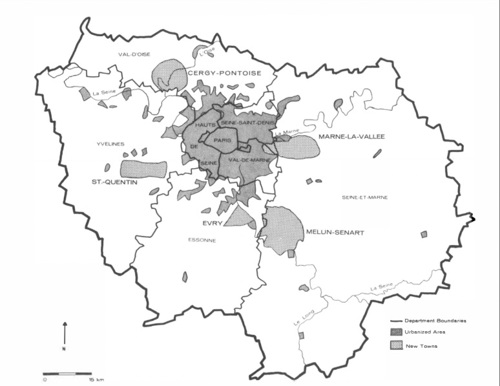
Figure 3.1: Location of Paris region new towns. Source: Rubenstein[54].
4.2 Overview
A strong national vision in France saw the five new towns of Cergy-Pontoise, Marne-le-Vallée, Quentin-en-Yvelines, Evry and Sénart developed in the region around Paris from 1965. Each had a Master Plan for Development and Urban Planning (SDAU) creating a mechanism for this to occur. All the new towns were based on existing urban area and intended to absorb up to 500,000 residents, with an overall projected population of some four and half million people, later revised downward to 1.7 million[55] .
In a strategy of “deconcentrated concentration” of people and jobs, the new towns were intended to fix earlier suburban expansion problems caused by isolated housing estates and urban sprawl around Paris[56]. The Paris region new towns offer lessons on adaptability of planned settlements including on governance and planning coherence, economic diversification, rapid housing provision at scale, regional transport infrastructure, and more recently, specific town and neighbourhood examples of liveable and popular placemaking.
The new towns were urban “poles” developed as part of a national urban programme to provide housing and jobs away from the overheated, unaffordable central Paris. The new towns offered some important key features, such as affordable housing, good jobs and pleasant green environments, but their 20th century principles for designing housing and places have not always stood the test of time. More recent new and redeveloped neighbourhoods have proved more popular and sustainable by following a traditional town design and masterplanning approach to their placemaking.
4.3 Planning frameworks
The Paris new towns were planned to deconcentrate economic growth and solve urban problems including the rapid growth of low-amenity suburban sprawl by developing a polycentric spatial planning model from a highly centralised one[57]. Established at 25-30 kilometres distance from central Paris, the intention was to provide “new centralities with the suburbs”. These would be good places to live and work within a Paris economic agglomeration, initially using taxation and administrative advantages to support them[58]. Young middle class people were the dominant new town pioneers, but social mix was an aim from the outset[59]. Today, the new towns have aged demographically, as have places elsewhere in France.
Although the Paris region new towns have not been as demographically or economically important as planned, they have diversified jobs and economic activity. They provide business districts, administrative centres, major company headquarters and research centres, and development around airports[60]. The new towns have contributed significantly to the socio-spatial organisation of Paris’s suburbs by guiding sprawl into more acceptable spatial forms for their 7.35 million residents (as of 2010) [61].
The planning of the Paris region new towns is complex but has benefited from a regional focus. This provides some integrating planning structures that help overcome policy fragmentation. Land costs have been kept down using a ‘ZAD’ (deferred development zone) system. According to James Rubenstein:
“Zone d'Amenagement Différe (deferred development zone) [refers to] an area established by government decree within which prices of land are frozen at the level of one year prior to the decree. The ZAD technique is used to discourage speculation as well as to keep prices low for land to be acquired. It has been used quite liberally in the new towns[62]”.
Less positively, transport planning control over Parisian suburbs is fragmented across seven counties which manage and fund most of the transportation network[63].
However, sixty percent of this region is within the Métropole du Metro (Metropolis of Greater Paris) which provides a strong coordinating framework. The Metropolis of Greater Paris is:
“a dense, urban inter-municipal area that includes the city of Paris, 122 municipalities from the three departments of Hauts-de-Seine, Seine-Saint-Denis and Val-de-Marne, and 7 municipalities from Essonne and Val d'Oise”[64].
Within the Paris region there are twelve intercommunal cooperative territories which have planning and development functions. Cross-territory management is an emerging trend encouraged by the French government to achieve service-provision efficiencies at scale[65]. French national laws meanwhile require regional and local plans to address environmental and 25 percent local affordable housing requirements. Public bodies have additional capacities to demand affordable housing on publicly owned land parcels. This:
“provided Paris with a tool for regulating its growth, with the aim of limiting the demographic and physical development of the capital as well as its inner suburbs.”[66]
4.4 Governance structures
France’s national government retains a central role in structuring planning in the Paris region, Île-de-France. The key moment in the constitution of the Paris urban region was 1960, when a General Development and Organization Plan for the Paris Region (PADOG) was published[67]. A strong focus on closely studying and understanding urban conditions and providing “a new institutional system to guide their growth”[68] characterized planning for the new towns in the Île-de-France region in the 1960s and 1970s.
This included a Development Corporation (the Etablissement Public d’Aménagement) created to manage the new towns’ development[69]. A delivery vehicle called the syndicate for community development (Syndicat Communautaire d'Amenagement), was instituted which amalgamated governance of local governments operating within the territory of each of the new towns[70].
After some devolution locally in the 1980s, the more recent establishment of the Greater Paris Metropolis in 2016 as a spatial, governance and planning entity has seen some recentralisation of power over planning from local authorities to the regional level[71]. This makes different scales of planning join up: “Policies in the Île-de-France regional plan must be incorporated into municipal plans and plans developed by inter-communal institutions.”
It is also noted “local plans incorporate zoning and thus directly link the policy goals of the national and regional governments to on-the-ground development requirements”[72]. Part of the structure of Metropole du Grand Paris is also a mandate to meet regional level policy goals for town planning including for the new towns[73].
4.5 Thematic discussion
Consistent vision, governance and planning policy focus
Positive elements include consistent national strategic and policy focus that emphasises cooperation at the regional scale. Along with financing instruments this has helped support the economic viability of new towns. The Metropolis of Greater Paris is critical as a regional scale governance, strategic planning, policy and structure and financing vehicle in the area around Paris. Treating new towns collectively as a kind of linked regional settlement form can offer an additional economic centre of gravity to a dominant central city. This can help offset the problems caused by a central city’s overheated economy and housing market. It can also help speed up the delivery of affordable housing and jobs and make liveable places.
4.6 Land use and transport planning policy to support affordability and accessibility
Despite a complex governance and planning context a range of planning instruments have supported the Paris new towns. These include the ‘ZAD’ (deferred development zone) system and 25 percent local affordable housing requirements which have helped lower new town housing costs by keeping land costs low and a percentage of housing affordable. Meanwhile, transport infrastructure that spatially links the new towns has helped underpin the around 1.5 million new jobs that were created in the Paris region between 1968 and 2018[74]. The RER and Transilien rail/tram network have been instrumental in creating good links to and between some new towns, and created subcentre economic locations within them[75].
In the Paris region new towns, targeted regional transport development has been pursued in combination with the programme of decentralising, polycentric urban growth. Proximity to RER stations has increased economic activity – primarily of urban jobs[76]. Transport oriented development nodes have also been developed through area development contracts (‘Contrats de développement territorial’). These “set targets for housing construction, economic development and public facilities in areas around the future automatic metro stations” [77].
4.7 Learning from earlier garden towns, garden suburbs and 20th century place models
This was not the first time new towns were developed around Paris. A 1920s round of French garden towns and suburbs in the Paris region, such as Suresnes on the western edge of Paris (designed by Henri Sellier), are still highly attractive living environments. These garden cities are an important context for the post war French new towns because the planners for the 1960s new towns drew a number of elements from them. These included success in attracting people and jobs, a context for public art and incorporating the natural landscape[78]. Yet in placemaking terms, while planners originally ‘tried to take into account their nature resources in the urban plan’[79] they included few other garden city model ‘place’ elements.
Today the Paris region new towns are looking in more detail at the garden city model’s relevance to making liveable places. The 1960s new towns were explicitly organised to be very different to the ‘grands ensembles’ (large scale) high rise housing estates that came before them[80]. Instead, they focused on “high modernist” experiments with housing design, often with very large scale town centre architecture, such as monumental residential architecture by Ricardo Bofill, and Les Arènes de Picasso residential buildings, designed by Manuel Núñez Yanowsky in the Noisy-le-Grand residential area in Evry (known as ‘Les Camemberts’ and ‘Les Pyramides’ because of their unusual shapes). They also incorporated pieces of ‘land art’, use of modern materials and experimental system building techniques, such as by Dani Karavan at Cergy-Pontoise [81].
Such experimentation has proved expensive in terms of social and environmental costs, spatial impacts and physical maintenance problems[82]. It is increasingly being retrofitted at more human scale following traditional placemaking approaches. The places now being made or remade in the new towns are closer in design terms to the 1920s garden suburbs that came before. This suggests successful placemaking models should not be ignored even when they don’t fit the dominant architectural ideas of the time.

4.8 Learning from the new towns’ placemaking experience over time
Residents moving to new towns identified them positively as being “a city in the countryside” with easy access to nature, abundant green space in neighbourhoods with a village character, and walkability on a town-wide pedestrian network away from traffic, sometimes on raised walkways. Access to private gardens, services, facilities and public transport in town and neighbourhood centres were attracting elements[83]. Yet the new towns began with a suburban approach which made it harder to maintain sufficient density to underpin urban services and facilities[84].
More positively, there has been an increasing focus on achieving density around transport nodes, high density centres, and the evolution of neighbourhood design in some of the new towns to emphasise liveable place qualities. There is also proving to be space for hybrid approaches to placemaking. such as the Sycomore eco quartier in Bussy-Saint-Georges on the edge of Marne-le-Vallée. This mixes modernist architectural housing styles with green construction and place features in an explicitly ‘eco’ approach.
Facilitating social and income mix was a deliberate aim from the outset of the new towns. All the same, tenures are dominated by social housing and housing for sale, with little private rental housing available[85]. Social mix has latterly increased in some of the new towns by bringing in more affluent residents, a change not all welcome[86]. Today the engagement of residents is reinforced by the requirements of planning law to consult local communities on proposed developments but there is little town-wide engagement from below[87].
At large geographical scale, Paris region’s new towns have strong landscape qualities, with neighbourhoods interspersed with parks and protected natural areas. The urban context intertwined with the new towns is complex – including suburban housing estates, middle class and working-class neighbourhoods, social housing estates, and “legacies of old urban fabric” of existing villages and towns[88].
This was reflected in various associations that developed around the new towns to defend existing places’ traditional qualities of rural character, local green space, access to countryside landscapes, existing land ownership, and traditional village. This succeeded at Champs and Croissy-Beaubourg near Marne-le-Vallée and Cergy village against what was seen as the problematic design of the Cergy-Pontoise new town development[89].
4.9 Different kinds of placemaking partnerships for new towns
The more recent placemaking examples of Val d’Europe and Le Plessis-Robinson areas within Marne-le-Vallée new town demonstrate walkable, mixed use, medium density places with traditional residential architecture. These have managed to avoid the problems created previously of overly large, hard-to-maintain housing structures and public spaces. Val d’Europe emerged from partnership working between the French state and the Disney Corporation to help design the place qualities of the final part of the 40-kilometre linear city of Marne-le-Vallée[90]. It was intended as “an opportunity to stimulate a new development of the eastern section of the new town and produce a major tourist attraction” [91].
In placemaking terms, Val d’Europe employed a traditional block and street form, making human-scaled, walkable neighbourhoods and limiting and carefully locating car access and parking” [92]. As of 2019, 12,000 housing units had been built in five districts centred on local centres, with Disney developing 6,000 of them[93]. Such examples reflect a strong preference in the housing market, among consumers, by developers, and among the region’s political leaders, for placemaking that produces places with these attractive design qualities.

4.10 Adaptability and flexibility: Levers and barriers
The range of new towns developed around Paris since the 1960s offer lessons on adaptability and flexibility in a number of themes. These themes include regional strategic and land use planning, regional transport planning, managing complex governance arrangements over time, development financing, affordable land and housing provision, landscape and green infrastructure features, and liveable placemaking through ‘concentrated deconcentration’.
Planners internationally can learn from the Paris region new towns’ largely failed experiments in monumental residential architecture and grandiose placemaking in a suburban context. These are their least successful elements. Policy makers since have started to develop places at a more human and urban scale, showing a willingness to flexibly adapt the approach. This has meant avoiding a strictly ‘modernist’ architectural vision or car-dependent suburban practice, despite these approaches being dominant in many urban contexts internationally.
The Paris region new towns are now showing in places like Val d’Europe that traditional placemaking produces commercial viability, resident popularity and sustainable design qualities. These approaches already align with key urban design principles for making high quality new places. They would therefore be relevant wherever new towns may be located internationally.
Additionally, some existing new towns globally face problems with their housing and place quality. Paris region new towns also provide some worked examples, such as Le Plessis-Robinson, of how to retrofit existing new towns. These forms of new town development and renewal show how new towns can be adapted once built, or new parts of them built, to a human-scaled masterplanning model.